
Um eine globale Abdeckung zu erreichen, bestehen GNSS-Systeme aus einem...
WeiterlesenIf you have followed our series of articles up to this point, you already know that navigation using GPS or other GNSS systems is based on the evaluation of continuously emitted signals. These signals naturally come from satellites orbiting the Earth. In order to achieve global coverage, GNSS systems consist of a network of several satellites that move along specific routes. In this article, we will take a closer look at how the satellites are organized. We will not only focus on the GPS system, but also take a look at other navigation systems such as GLONASS, Galileo or BeiDou.
The basics - How does GNSS/GPS work?
GPS is based on a network of satellites that orbit the Earth and continuously send out signals. These are received by GPS receivers on the ground. To calculate an accurate position, a GPS receiver needs signals from at least four satellites. Each satellite sends signals with precise time information and its own orbital parameters.
A detailed description of how the GPS position is determined is explained in our article How GPS Works: How Your Device Knows Where You Are
GPS as an example
GPS is so well known as a positioning system that it has become synonymous with the actual term GNSS in common parlance. We will use the Global Positioning System (GPS) as a reference in this section to explain in general terms how navigation satellites are organized – other systems work in a similar way. Ready? Let’s get started.
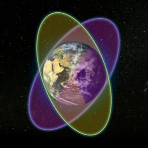
GPS satellites move around the Earth in a medium Earth orbit (MEO) in a very precise and well-defined way. Here are the key details of their movement:
Orbital properties
Altitude
GPS satellites orbit the Earth at an altitude of about 20,200 kilometers (about 12,550 miles) above the Earth’s surface.
Orbital period
Each satellite orbits the Earth in about 12 hours.
Orbital planes
There are six orbital planes, each inclined at 55 degrees to the equator. These planes are evenly distributed around the equator.
Number of satellites
Each orbital plane typically contains 4 satellites, giving the GPS constellation a total of 24 operational satellites. Additional satellites are often in orbit as spares or for additional coverage.
Additional satellites
In addition to the 24 main satellites, there are usually several additional satellites in orbit. These additional satellites serve as backups and help improve the reliability and accuracy of the system. According to recent counts, there may be about 30 to 32 GPS satellites in orbit, including these backup satellites.
Orbital motion
Inclination
The 55-degree inclination means that the satellites can cover a large part of the Earth’s surface and reach latitudes up to about 55 degrees north and south.
Keplerian orbits
GPS satellites follow nearly circular orbits that are governed by Kepler’s laws of planetary motion, which describe the motion of objects in orbit around a larger body.
Gravitational forces
The main force acting on GPS satellites is the Earth’s gravity, which keeps them in their orbits. They are also subject to minor gravitational perturbations from the Moon and Sun, which are taken into account in their navigation models.
Synchronization and timing
Atomic clocks
Each GPS satellite has high-precision atomic clocks that are synchronized with systems on Earth. These clocks provide the precise time needed for GPS positioning.
Transmission signals
The satellites continuously transmit signals with their current time and orbit information. These signals are used by GPS receivers on Earth to calculate the receiver’s position by triangulating the signals from multiple satellites.
Maintenance and Control
Ground control
The GPS constellation is monitored and maintained by a network of ground control stations. These stations track the satellites, update their orbital parameters, and ensure that their signals remain accurate.
Orbital adjustments
Occasionally, satellites need to adjust their orbits to maintain the optimal configuration. These adjustments are made using small onboard thrusters.
To recap, GPS satellites orbit the Earth in medium Earth orbits, following trajectories that allow them to continuously transmit accurate positioning data to receivers around the globe. Their movement and position are carefully monitored and maintained by a network of ground control stations.
Satellites everywhere - How many satellites orbit the Earth?
The total number of satellites orbiting the Earth includes a variety of navigation, communications, weather, scientific and military satellites. Focusing specifically on navigation satellites, several global systems contribute to this number:
GPS (Global Positioning System)
Approximately 30–32 satellites (including operational and spare satellites).
GLONASS (Global Navigation Satellite System)
About 24-27 operational satellites
Galileo (Europäische Union)
About 24 operational satellites and some additional spare satellites in orbit, making a total of about 26 to 30 satellites.
BeiDou (China)
Approximately 35 operational satellites.
NavIC (Indian Regional Navigation Satellite System)
7 operational satellites.
QZSS (Quasi-Zenith Satellite System, Japan)
4 operational satellites.
Total number of navigation satellites
If you add these numbers together:
- GPS: ~30-32
- GLONASS: ~24-27
- Galileo: ~26-30
- BeiDou: ~35
- NavIC: 7
- QZSS: 4
This gives a total number of navigation satellites in orbit of approximately 126-135.
Total number of all satellite types
In addition to navigation satellites, there are thousands of other satellites in various orbits around the Earth. Here are some estimates for early 2024:
Communication satellites
Hundreds, including those in geostationary orbit (GEO) and low Earth orbit (LEO).
Earth observation satellites
Hundreds, for purposes such as weather forecasting, environmental monitoring and reconnaissance.
Science and research satellites
Dozens launched by space agencies such as NASA, ESA and others for scientific missions.
Military satellites
An unknown but significant number used for reconnaissance, communications and other defense purposes.
Commercial satellites
An increasing number, especially with the emergence of private space companies such as SpaceX launching large constellations for global internet coverage (e.g. Starlink).
Current estimates
By early 2024, there will be about 8,000 to 9,000 active satellites in Earth orbit, a number that is rapidly increasing due to the launch of mega-constellations such as SpaceX’s Starlink and other commercial projects.
Determining a position should not be a problem given the number of GNSS satellites worldwide. However, it does happen from time to time that no position can be determined. You can read about the factors that contribute to this in our article The exact position: What factors influence the GPS signal?
(No) crash in space
How come there are no collisions with all those satellites? The key is the altitude at which satellites orbit the Earth. The different global navigation satellite systems (GNSS) operate at different altitudes depending on their design and planned coverage. Here are the typical orbital altitudes for the main GNSS constellations:
GPS (Global Positioning System)
- Orbital altitude: Approximately 20,200 kilometers (12,550 miles)
- Orbital period: Approximately 12 hours
- Orbit type: Medium Earth orbit (MEO)
GLONASS (Global Navigation Satellite System)
- Orbital altitude: Approximately 19,100 kilometers (11,870 miles)
- Orbital period: Approximately 11 hours 15 minutes
- Orbit type: Medium Earth orbit (MEO)
Galileo (European Union)
- Orbital altitude: Approximately 23,222 kilometers (14,430 miles)
- Orbital period: Approximately 14 hours
- Orbit type: Medium Earth orbit (MEO)
BeiDou (China)
- Orbital altitude:
- MEO satellites: Approximately 21,528 kilometers (13,370 miles)
- GEO satellites: Geostationary Earth orbit at approximately 35,786 kilometers (22,236 miles)
- IGSO satellites: Inclined geosynchronous orbits at approximately 35,786 kilometers (22,236 miles)
- Obituary period:
- MEO: Approximately 12 hours
- GEO and IGSO: Approximately 24 hours
NavIC (Indian Regional Navigation Satellite System)
- Orbit altitude: Approximately 36,000 kilometers (22,369 miles)
- Orbit period: Approximately 24 hours
- Orbit type: Geosynchronous orbit (GSO), including geostationary and inclined geosynchronous orbits
QZSS (Quasi-Zenith Satellite System, Japan)
- Orbital altitude: Approximately 35,786 kilometers (22,236 miles)
- Orbital period: Approximately 24 hours
- Orbit type: Highly inclined elliptical orbit and geosynchronous orbit
In summary:
- GPS, GLONASS and Galileo operate primarily in medium Earth orbit (MEO).
- BeiDou uses a combination of MEO, geostationary Earth orbit (GEO) and inclined geosynchronous orbit (IGSO).
- NavIC and QZSS primarily use geosynchronous and geostationary orbits.
These different orbit altitudes and configurations allow each system to provide optimal coverage and accuracy for the intended regions and global services without interfering with each other.
Learn more about how to determine the GPS signal faster and more accurately in our article AGPS – A technology to improve GPS performance
Conclusion
Our quest for improved technology may advance, but this cannot happen without environmental change. To create and establish systems that provide ubiquitous services and global availability, satellites are the first choice for data communications. As systems become larger and more complex, more satellites are expected to populate the space around Earth. Navigation is one of these services that is now heavily integrated into everyday life. Navigation uses a relatively small number of satellites to ensure global coverage. However, other system manufacturers have also taken a look at the (still) free spots in space. Many technologies already exist, and more will follow. If you ever have the opportunity to travel into space, be careful not to get hit by one of the nearly 9,000 satellites.
Title image: Alexander Ant / pexels
Are you ready to explore GPS tracking solutions for your business or personal use?
Contact us today to discuss the perfect device for your needs!
Or take a look at our online shop.
Related articles

Mehr als GNSS/GPS: Alternative Systeme zur Positionsbestimmung auf der Erde
Wenn wir an Standortbestimmung denken, kommen uns häufig globale Navigationssatellitensysteme...
Weiterlesen
Die exakte Position: Welche Faktoren beeinflussen das GPS-Signal?
Die Zuverlässigkeit und Genauigkeit von GPS-Signalen hängt von einer Vielzahl...
Weiterlesen